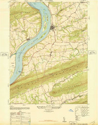
1947 Map of Halifax
USGS Topo · Published 1947About this map
The Susquehanna River dominates this mid-century landscape, carving a wide path through the ridge-and-valley terrain of Dauphin and Perry Counties. Large river islands such as Clempson Island, Bressler Island, and Haldeman Island punctuate the waterway, reflecting the complex alluvial patterns of the Susquehanna. Along the banks, the town of Halifax and the borough of New Buffalo serve as primary hubs, connected by a network of rural roads that navigate the steep slopes of Peters Mountain and Second Mountain.
Find a feature on this map
41 named features on this map. Tap any name to fly to it.
Don’t see what you’re looking for? This feature index may not catch every label — zoom into the map to look around manually.
Map Details
Editions of this 1947 Halifax Map
3 editions found
Other maps of this area

1892 · Harrisburg
USGS Topo · 1:62,500

1893 · Millersburg
USGS Topo · 1:62,500

1899 · Harrisburg
USGS Topo · 1:62,500

1907 · New Bloomfield
USGS Topo · 1:62,500

1907 · Millerstown
USGS Topo · 1:62,500

1924 · Harrisburg
USGS Topo · 1:62,500

1943 · Millerstown
USGS Topo · 1:62,500

1943 · Millersburg
USGS Topo · 1:62,500

1943 · Harrisburg
USGS Topo · 1:62,500

1943 · New Bloomfield
USGS Topo · 1:62,500