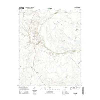
2016 Map of Halifax
USGS Topo · Published 2016About this map
The Roanoke River carves a sweeping path along the boundary between Halifax and Northampton counties, defining the landscape of this 2016 survey. On its western bank, the historic settlement of Halifax serves as a focal point, surrounded by a network of smaller communities including Pender, Ruggles, and Pea Hill. The terrain transition is marked by the broad flats of Occoneechee Neck to the east and the intricate waterways of Conoconnara Swamp to the south. This modern topographic study reveals a deeply agricultural character, dotted with family-named landmarks like the Johnston Farm Airport and remote locales such as Mud Castle. Local geography is further defined by the drainage of Quankey Cr and Little Quankey Cr, which meander toward the river through a region where rural roads like Old Chantilly Rd and Burgwin Rd trace long-standing land divisions and plantation boundaries.
Find a feature on this map
43 named features on this map. Tap any name to fly to it.
Don’t see what you’re looking for? This feature index may not catch every label — zoom into the map to look around manually.
Map Details
Editions of this 2016 Halifax Map
This is the sole edition of this map. No revisions or reprints were ever made.
Other maps of this area

1953 · Norfolk
USGS Topo · 1:250,000

1960 · Dawson Crossroads
USGS Topo · 1:24,000

1961 · Enfield
USGS Topo · 1:24,000

1962 · Scotland Neck
USGS Topo · 1:24,000

1974 · Halifax
USGS Topo · 1:24,000

1974 · Boones Crossroads
USGS Topo · 1:24,000
1974 · Roanoke Rapids
USGS Topo · 1:24,000
1974 · Weldon
USGS Topo · 1:24,000

1974 · Darlington
USGS Topo · 1:24,000
1974 · Jackson
USGS Topo · 1:24,000