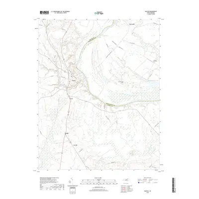
2019 Map of Halifax
USGS Topo · Published 2019About this map
Halifax serves as a central anchor on this coastal plain landscape, where the wide bend of the Roanoke River separates Halifax County from Northampton County. The town's historic street grid, featuring names like Saint David St and E Pittsylvania St, sits just above the confluence of Quankey Creek and the river. Further east, the large agricultural peninsula known as Occoneechee Neck is bounded by a massive southern loop of the Roanoke, characterized by extensive wetlands and drainage into Occoneechee Creek. Moving south away from the river, small rural clusters like Pender, Ruggles, and Pea Hill line the transport corridors, while the southern reaches are dominated by the dense bottomlands of Conoconnara Swamp. Notable landmarks such as the Johnston Farm Airport and the descriptively named Mud Castle reflect the mix of aviation history and local place-naming traditions common to this river valley region.
Find a feature on this map
43 named features on this map. Tap any name to fly to it.
Don’t see what you’re looking for? This feature index may not catch every label — zoom into the map to look around manually.
Map Details
Editions of this 2019 Halifax Map
This is the sole edition of this map. No revisions or reprints were ever made.
Other maps of this area

1953 · Norfolk
USGS Topo · 1:250,000

1960 · Dawson Crossroads
USGS Topo · 1:24,000

1961 · Enfield
USGS Topo · 1:24,000

1962 · Scotland Neck
USGS Topo · 1:24,000

1974 · Halifax
USGS Topo · 1:24,000

1974 · Boones Crossroads
USGS Topo · 1:24,000
1974 · Roanoke Rapids
USGS Topo · 1:24,000
1974 · Weldon
USGS Topo · 1:24,000

1974 · Darlington
USGS Topo · 1:24,000
1974 · Jackson
USGS Topo · 1:24,000