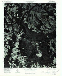
1976 Map of Halifax
USGS Topo · Published 1979About this map
The Roanoke River dominates this mid-1970s orthophotoquad, carving a wide, dark path through a mosaic of agricultural fields and dense woodlands. This specific type of imagery, prepared from 1976 aerial photography, reveals the precise land-use patterns of the era, where the sharp contrasts between light-toned cleared fields and dark forest canopies highlight the region's rural character. Small rural communities like Pender and Ruggles appear as clusters of development along the existing road network, illustrating how local settlement patterns remained closely tied to the topography of the river basin. To the north, the label for Mud Castle marks a specific point of local interest near the river's winding course. This document is particularly valuable for researchers tracing the physical evolution of the North Carolina landscape before modern expansion, capturing the exact state of field boundaries and drainage patterns at a time when traditional farming still defined the local economy.
Find a feature on this map
4 named features on this map. Tap any name to fly to it.
Don’t see what you’re looking for? This feature index may not catch every label — zoom into the map to look around manually.
Map Details
Editions of this 1976 Halifax Map
This is the sole edition of this map. No revisions or reprints were ever made.
Other maps of this area

1953 · Norfolk
USGS Topo · 1:250,000

1960 · Dawson Crossroads
USGS Topo · 1:24,000

1961 · Enfield
USGS Topo · 1:24,000

1962 · Scotland Neck
USGS Topo · 1:24,000

1974 · Halifax
USGS Topo · 1:24,000

1974 · Boones Crossroads
USGS Topo · 1:24,000
1974 · Roanoke Rapids
USGS Topo · 1:24,000
1974 · Weldon
USGS Topo · 1:24,000

1974 · Darlington
USGS Topo · 1:24,000
1974 · Jackson
USGS Topo · 1:24,000