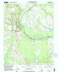
1997 Map of Halifax
USGS Topo · Published 2000About this map
The Roanoke River carves a dramatic bend through this portion of eastern North Carolina, defining the boundary between Halifax and Northampton counties. The town of Halifax serves as a focal point, situated where the CSX Transportation rail line crosses Quankey Creek. The geography is defined by the massive Occoneechee Neck, a peninsula of low-lying terrain nearly encircled by the river's path. Local infrastructure includes the State Prison and the Halifax County Technical Institute, reflecting the region's civic development.
Find a feature on this map
22 named features on this map. Tap any name to fly to it.
Don’t see what you’re looking for? This feature index may not catch every label — zoom into the map to look around manually.
Map Details
Editions of this 1997 Halifax Map
This is the sole edition of this map. No revisions or reprints were ever made.
Other maps of this area

1953 · Norfolk
USGS Topo · 1:250,000

1960 · Dawson Crossroads
USGS Topo · 1:24,000

1961 · Enfield
USGS Topo · 1:24,000

1962 · Scotland Neck
USGS Topo · 1:24,000

1974 · Halifax
USGS Topo · 1:24,000

1974 · Boones Crossroads
USGS Topo · 1:24,000
1974 · Roanoke Rapids
USGS Topo · 1:24,000
1974 · Weldon
USGS Topo · 1:24,000

1974 · Darlington
USGS Topo · 1:24,000
1974 · Jackson
USGS Topo · 1:24,000