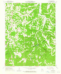
1964 Map of Halifax
USGS Topo · Published 1965About this map
Valles Mines sits on the western edge of this 1964 survey, where the border of Jefferson and St. Francois counties meets the banks of Joachim Creek. This terrain is characterized by deep hollows and high ridges like McMullen Ridge, which separates the drainages of Plattin Creek and McMullen Branch. The map reveals a dense network of local family history through numerous small burial grounds and rural congregations, including the German Ch Cem, Old German Cem, and Charter Ch. To the south, the Big River carves a winding path near the settlement of Halifax, while recreational developments appear at Lake Lacawanna and Laguna Palma. This era in eastern Missouri shows the persistence of early agricultural and mining centers like Flucom and Oakvale alongside mid-century infrastructure like the local Radio Tower.
Find a feature on this map
47 named features on this map. Tap any name to fly to it.
Don’t see what you’re looking for? This feature index may not catch every label — zoom into the map to look around manually.
Map Details
Editions of this 1964 Halifax Map
2 editions found
Other maps of this area

1901 · De Soto
USGS Topo · 1:125,000

1904 · Farmington
USGS Topo · 1:62,500

1905 · Bonneterre
USGS Topo · 1:62,500

1906 · Farmington
USGS Topo · 1:62,500

1915 · Crystal City
USGS Topo · 1:62,500

1930 · De Soto NE
USGS Topo · 1:24,000

1931 · De Soto SE
USGS Topo · 1:24,000

1949 · Saint Louis
USGS Topo · 1:250,000

1949 · Rolla
USGS Topo · 1:250,000

1949 · Crystal City
USGS Topo · 1:62,500