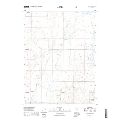
2018 Map of Halleck SW
USGS Topo · Published 2018About this map
Lamoille Valley serves as the central geographic feature of this Elko County landscape, where the high desert meets the rising elevations of the Humboldt National Forest. This 2018 survey reveals a modern ranching and outdoor recreation corridor defined by a network of seasonal drainages and local access roads. The northeast corner is marked by Lake Phyllis and Bills Fishpond, suggesting the localized management of water in this arid environment. Significant historical and modern access points are noted through routes like Fort Halleck Rd and Bottari Ranch Rd, while the Lamoille-Gardner Creek Tr indicates a shift toward trail-based navigation in the southeastern high ground. The terrain transitions from the wide valley floor into the steep topography of Thorpe Canyon, fed by numerous small waterways including Lamoille Cr and Thorpe Cr.
Find a feature on this map
26 named features on this map. Tap any name to fly to it.
Don’t see what you’re looking for? This feature index may not catch every label — zoom into the map to look around manually.
Map Details
Editions of this 2018 Halleck SW Map
This is the sole edition of this map. No revisions or reprints were ever made.
Other maps of this area

1935 · Halleck
USGS Topo · 1:125,000

1955 · Elko
USGS Topo · 1:250,000

1958 · Elko
USGS Topo · 1:250,000

1962 · Elko
USGS Topo · 1:250,000

1962 · Boyd Reservoir
USGS Topo · 1:24,000

1962 · Ryndon
USGS Topo · 1:24,000

1962 · Lee
USGS Topo · 1:62,500

1962 · Lamoille
USGS Topo · 1:62,500

1965 · Elko
USGS Topo · 1:250,000
1970 · Soldier Peak
USGS Topo · 1:24,000