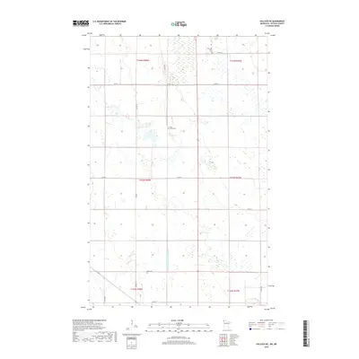
2019 Map of Hallock NE
USGS Topo · Published 2019About this map
State Ditch Number Eightyfour State Ditch Number Eightyfour anchors the hydrology of this Kittson County landscape, a testament to the extensive drainage networks that transformed this corner of northern Minnesota for agriculture. The terrain is marked by a precise grid of rural routes, including Co Rd 1 and Co Rd 8, which segment the land into townships and sections. Scattered across this remote landscape are quiet markers of early settlement history. The Tom Lako Farm Cem in the north and the Holy Rosary Cem near the center point to the family farms and parish communities that established roots in the Red River Valley region. These small, isolated burial grounds, along with Sikar Cem, serve as primary landmarks in an otherwise open area defined by section lines and field boundaries.
Find a feature on this map
22 named features on this map. Tap any name to fly to it.
Don’t see what you’re looking for? This feature index may not catch every label — zoom into the map to look around manually.
Map Details
Editions of this 2019 Hallock NE Map
This is the sole edition of this map. No revisions or reprints were ever made.
Other maps of this area

1918 · Hemmington
USGS Topo · 1:62,500

1941 · Hallock
USGS Topo · 1:62,500

1952 · Thief River Falls
USGS Topo · 1:250,000

1956 · Thief River Falls
USGS Topo · 1:250,000

1957 · Thief River Falls
USGS Topo · 1:250,000

1966 · Skull Lake
USGS Topo · 1:24,000
1966 · Skull Lake SW
USGS Topo · 1:24,000

1967 · Thief River Falls
USGS Topo · 1:250,000
1974 · Hallock NE
USGS Topo · 1:24,000
1974 · Orleans
USGS Topo · 1:24,000