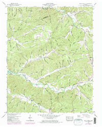
1950 Map of Halls Creek
USGS Topo · Published 1974About this map
Kentucky Lake defines the western edge of this landscape, its waters reaching into the mouths of hollows along the Tennessee River valley. This mid-century survey captures a rural landscape where local community life is anchored by family-named landmarks and small-scale institutions like Ellis Grove School and Elizabeth Sch. The settlement pattern is deeply connected to the network of watercourses and ridges, with homes and small farms concentrated along Halls Creek and Richland Creek.
Find a feature on this map
122 named features on this map. Tap any name to fly to it.
Don’t see what you’re looking for? This feature index may not catch every label — zoom into the map to look around manually.
Map Details
Editions of this 1950 Halls Creek Map
3 editions found

Other maps of this area

1931 · Erin
USGS Topo · 1:62,500

1936 · Gorman
USGS Topo · 1:24,000

1936 · Tantrough Hollow
USGS Topo · 1:24,000

1936 · McKinnon
USGS Topo · 1:24,000

1936 · Woolworth
USGS Topo · 1:24,000

1936 · Stewart
USGS Topo · 1:24,000

1936 · Halls Creek
USGS Topo · 1:24,000

1936 · Johnsonville
USGS Topo · 1:24,000

1936 · Harmon Creek
USGS Topo · 1:24,000

1936 · Waverly
USGS Topo · 1:24,000