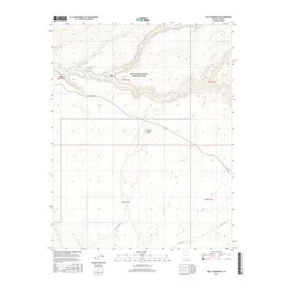
2017 Map of Halls Crossing NE
USGS Topo · Published 2017About this map
Lake Powell defines the northern landscape of this region within the Glen Canyon National Recreation Area. The map records the intersection of modern infrastructure and significant pioneer history, most notably the path of the Hole In The Rock Trail as it traverses the southern section of the quadrangle. This historic route represents the challenging 19th-century expedition through the sandstone breaks of the Colorado River corridor. While the settlement at Halls Crossing serves as a primary access point for the reservoir, the surrounding terrain remains characterized by deep drainage systems like North Gulch and the E Fork Lake Canyon. Aviation access is provided by the Cal Black Memorial Airport, situated on a high mesa above the winding lake. The road network, including Halls Crossing Rd and Nokai Dome Rd, links these remote outposts across the high desert plateaus.
Find a feature on this map
13 named features on this map. Tap any name to fly to it.
Don’t see what you’re looking for? This feature index may not catch every label — zoom into the map to look around manually.
Map Details
Editions of this 2017 Halls Crossing NE Map
This is the sole edition of this map. No revisions or reprints were ever made.
Other maps of this area

1886 · Henry Mountains
USGS Topo · 1:250,000

1892 · Henry Mountains
USGS Topo · 1:250,000

1952 · Mancos Mesa
USGS Topo · 1:62,500

1953 · Lake Canyon
USGS Topo · 1:62,500

1953 · Mt. Ellsworth
USGS Topo · 1:62,500

1954 · White Canyon 3 SW
USGS Topo · 1:24,000

1954 · Clay Hills 2 SW
USGS Topo · 1:24,000

1954 · Clay Hills 2 NW
USGS Topo · 1:24,000
1954 · Clay Hills
USGS Topo · 1:62,500

1956 · Escalante
USGS Topo · 1:250,000