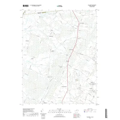
2019 Map of Hallwood
USGS Topo · Published 2019About this map
Accomack County and its border with Maryland's Worcester County and Somerset County define this coastal landscape on the Delmarva Peninsula. The terrain is characterized by a network of tidal creeks and drainage branches, including Assawoman Creek and Bullbegger Creek, which feed into the Chesapeake Bay. Settlement patterns follow the higher ground between these waterways, with historic communities like Temperanceville, Hallwood, and Atlantic serving as hubs for the surrounding agricultural lands. Notable local landmarks include several small airfields such as Sawyer Airport and High Hopes Airport, as well as religious centers like the Atlantic Baptist Church. The map reveals the intricate connection between land and water in this region, where roads like Chincoteague Road bridge the gap between inland settlements and the marshy coast, highlighting a rural economy shaped by both farming and maritime proximity.
Find a feature on this map
98 named features on this map. Tap any name to fly to it.
Don’t see what you’re looking for? This feature index may not catch every label — zoom into the map to look around manually.
Map Details
Editions of this 2019 Hallwood Map
This is the sole edition of this map. No revisions or reprints were ever made.
Other maps of this area

1901 · Snow Hill
USGS Topo · 1:62,500

1942 · Kingston
USGS Topo · 1:24,000

1942 · Mappsville
USGS Topo · 1:24,000

1942 · Wallops Island
USGS Topo · 1:24,000

1942 · Saxis
USGS Topo · 1:24,000

1942 · Parksley
USGS Topo · 1:24,000

1943 · Parksley
USGS Topo · 1:31,680

1943 · Saxis
USGS Topo · 1:31,680

1943 · Mappsville
USGS Topo · 1:31,680

1943 · Chincoteague West
USGS Topo · 1:31,680