
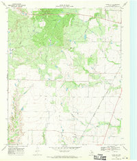
1966 Map of Halsell Ranch
USGS Topo · Published 1969About this map
The North Wichita River meanders through a landscape of deep draws and breaks along the border of Foard and Knox Counties. This mid-1960s survey captures the cattle-working infrastructure of the region, anchored by the Halsell Ranch and Ellis Ranch. Unlike more densely settled agricultural areas, this territory is defined by its wide-open ranching operations and essential water-extraction points like the West End Windmill and Deadman Windmill. The topography reveals a transition between the northern Middle Beaver Creek drainage and the complex erosional patterns surrounding Deadman Creek. Several Gravel Pits indicate local resource extraction, while West Camp serves as a distinct outlier in this sparsely populated stretch of the Texas Rolling Plains.
Find a feature on this map
12 named features on this map. Tap any name to fly to it.
Don’t see what you’re looking for? This feature index may not catch every label — zoom into the map to look around manually.
Map Details
Editions of this 1966 Halsell Ranch Map
This is the sole edition of this map. No revisions or reprints were ever made.
Other maps of this area

1954 · Wichita Falls
USGS Topo · 1:250,000

1958 · Wichita Falls
USGS Topo · 1:250,000

1966 · Truscott North
USGS Topo · 1:24,000

1966 · Colwell Creek
USGS Topo · 1:24,000

1966 · Truscott South
USGS Topo · 1:24,000

1966 · Gilliland
USGS Topo · 1:24,000

1966 · Crowell
USGS Topo · 1:24,000

1966 · Vera
USGS Topo · 1:24,000

1966 · Thalia
USGS Topo · 1:24,000
1968 · Foard City
USGS Topo · 1:24,000