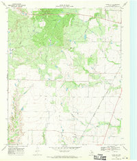
1968 Map of Foard City
USGS Topo · Published 1970About this map
The small settlement of Foard City serves as the focal point of this North Texas landscape, situated at the junction of local roads and the Atchison Topeka and Santa Fe railroad line. The terrain is defined by a dense network of drainage systems, including the branching paths of Beaver Creek and Middle Beaver Creek, which wind across the prairie toward the southeast. In the northern reaches of the quadrangle, the elevation rises toward Dixie Mound, while the western edge is shaped by the parallel courses of Good Creek and Little Good Creek. This 1960s era survey illustrates a rural economy tied to the land and the rails, showing the sparse but intentional placement of ranch roads and surveying lines that parcel out the plains. The presence of Salt Flat Creek and Raggedy Creek highlights the unique hydrological character of Foard County, where seasonal waterways have carved out subtle topographical shifts in the limestone-influenced soil.
Find a feature on this map
9 named features on this map. Tap any name to fly to it.
Don’t see what you’re looking for? This feature index may not catch every label — zoom into the map to look around manually.
Map Details
Editions of this 1968 Foard City Map
This is the sole edition of this map. No revisions or reprints were ever made.
Other maps of this area

1932 · Vivian
USGS Topo · 1:62,500

1954 · Wichita Falls
USGS Topo · 1:250,000

1955 · Lawton
USGS Topo · 1:250,000

1958 · Wichita Falls
USGS Topo · 1:250,000

1958 · Medicine Mound
USGS Topo · 1:62,500

1960 · Teacup Mountain
USGS Topo · 1:62,500

1966 · Truscott North
USGS Topo · 1:24,000

1966 · Halsell Ranch
USGS Topo · 1:24,000

1966 · Big Four Ranch
USGS Topo · 1:24,000

1966 · Crowell
USGS Topo · 1:24,000