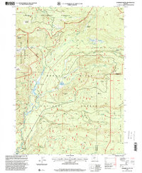
1997 Map of Hamaker Butte
USGS Topo · Published 2000About this map
Rogue River National Forest and the Umpqua National Forest meet in this 1990s survey, defined by the intricate hydrology of the upper Rogue River basin. The landscape is marked by the presence of several established campsites and historical locations, such as the Hurryon Camp (Site) and Muir Camp. A network of trails and primitive roads connects these points of interest, including the Bert Creek Trail and the Rogue-Umpqua Scenic Byway, which skirts the western edge of the high country. Dramatic elevation changes are highlighted by named peaks like Hamaker Butte and Sherwood Butte, while the water features transition from quiet spots like Soda Springs and Bobs Bog to the vertical drops of Cascade Falls and Mazama Falls. The northeastern corner of the map touches the boundary of Crater Lake National Park near Crescent Ridge, marking a significant intersection of federal land management during this era.
Find a feature on this map
54 named features on this map. Tap any name to fly to it.
Don’t see what you’re looking for? This feature index may not catch every label — zoom into the map to look around manually.
Map Details
Editions of this 1997 Hamaker Butte Map
This is the sole edition of this map. No revisions or reprints were ever made.
Other maps of this area

1891 · Ashland
USGS Topo · 1:250,000

1893 · Ashland
USGS Topo · 1:250,000

1897 · Ashland
USGS Topo · 1:250,000

1917 · Diamond Lake
USGS Topo · 1:125,000

1955 · Medford
USGS Topo · 1:250,000

1956 · Diamond Lake
USGS Topo · 1:62,500

1956 · Garwood Butte
USGS Topo · 1:62,500

1956 · Prospect
USGS Topo · 1:62,500

1957 · Medford
USGS Topo · 1:250,000

1958 · Medford
USGS Topo · 1:250,000