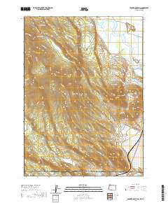
2020 Map of Hamaker Mountain
USGS Topo · Published 2020About this map
The Klamath River winds through the northeast corner of this high-elevation landscape, defining a borderland where Oregon meets California. To the west, the volcanic profiles of Hamaker Mtn and Chase Mtn dominate the horizon, crisscrossed by a network of logging and access roads like the Weyco West Hookup and Hamaker Mtn Rd. This area reflects a mid-20th-century transition toward managed timberlands and recreational access, with residential developments emerging near the river along Whispering Pines Dr.
Find a feature on this map
52 named features on this map. Tap any name to fly to it.
Don’t see what you’re looking for? This feature index may not catch every label — zoom into the map to look around manually.
Map Details
Editions of this 2020 Hamaker Mountain Map
This is the sole edition of this map. No revisions or reprints were ever made.
Other maps of this area

1886 · Modoc Lava Bed
USGS Topo · 1:250,000

1886 · Shasta
USGS Topo · 1:250,000

1889 · Klamath
USGS Topo · 1:250,000

1891 · Ashland
USGS Topo · 1:250,000

1892 · Modoc Lava-Bed
USGS Topo · 1:250,000

1893 · Ashland
USGS Topo · 1:250,000

1894 · Klamath
USGS Topo · 1:250,000

1894 · Shasta
USGS Topo · 1:250,000

1897 · Ashland
USGS Topo · 1:250,000

1934 · Macdoel
USGS Topo · 1:96,000