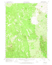
1961 Map of Hambone
USGS Topo · Published 1967About this map
The Great Northern railroad corridor defines this high-altitude landscape where the Shasta National Forest meets the Modoc National Forest. At the heart of the region lies Hambone, a central junction point served by the Great Northern Road and the Mc Cloud River Road. This 1961 field-checked survey reveals an environment shaped by volcanic activity and cold-storage geology, evidenced by the Deep Ice Caves, Mayfield Ice Cave, and prominent peaks like Hambone Butte and Porcupine Butte.
Find a feature on this map
47 named features on this map. Tap any name to fly to it.
Don’t see what you’re looking for? This feature index may not catch every label — zoom into the map to look around manually.
Map Details
Editions of this 1961 Hambone Map
2 editions found
Other maps of this area

1886 · Modoc Lava Bed
USGS Topo · 1:250,000

1892 · Modoc Lava-Bed
USGS Topo · 1:250,000

1932 · Bartle
USGS Topo · 1:96,000

1939 · Bartle
USGS Topo · 1:125,000

1950 · Bray
USGS Topo · 1:62,500

1952 · Timber Mountain
USGS Topo · 1:62,500

1952 · Medicine Lake
USGS Topo · 1:62,500

1954 · Alturas
USGS Topo · 1:250,000

1958 · Alturas
USGS Topo · 1:250,000

1961 · Hambone
USGS Topo · 1:62,500