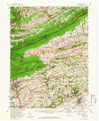
1956 Map of Hamburg
USGS Topo · Published 1966About this map
Blue Mountain serves as the dominant spine of this Pennsylvania landscape, separating the rural townships of Albany and Greenwich in Berks County from the valley settlements of Schuylkill County. The mid-century era is marked by the presence of institutions like the Kutztown State Teachers College and the Hawk Mountain Sanctuary, alongside industrial and recreational sites such as Onyx Cave and the Hamburg Reservoir. The Reading Railroad cuts through the river gaps, providing vital transport for towns like New Ringgold and Hamburg. Geologic and topographic interest is high near The Pinnacle and Blue Rocks, while the numerous rural schools like Steigerwalts Sch and Heinly Sch reflect the dispersed agricultural settlement pattern. The Appalachian Trail follows the ridge, offering a glimpse into the early recreational development of the Kittatinny Ridge.
Find a feature on this map
121 named features on this map. Tap any name to fly to it.
Don’t see what you’re looking for? This feature index may not catch every label — zoom into the map to look around manually.
Map Details
Editions of this 1956 Hamburg Map
2 editions found
Other maps of this area

1889 · Hazleton
USGS Topo · 1:62,500

1889 · Pottsville
USGS Topo · 1:62,500

1891 · Hazleton
USGS Topo · 1:62,500

1891 · Pottsville
USGS Topo · 1:62,500

1892 · Mahanoy
USGS Topo · 1:62,500

1893 · Hazleton
USGS Topo · 1:62,500

1893 · Mahanoy
USGS Topo · 1:62,500

1894 · Reading
USGS Topo · 1:62,500

1902 · Boyertown
USGS Topo · 1:62,500

1902 · Wernersville
USGS Topo · 1:62,500