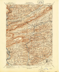
1911 Map of Hamburg
USGS Topo · Published 1944About this map
Blue Mountain serves as the dominant spine of this Berks and Schuylkill County landscape, naturally separating the industrial river corridor of Hamburg from the agricultural valleys of Albany and Greenwich townships. Captured at the turn of the century, the map reveals a sophisticated transportation network where the Lehigh Valley RR and Philadelphia and Reading RR snake through gaps and along creek beds like Ontelaunee Creek. The prominence of The Pinnacle overlooks a region defined by small, frequent settlements including Stony Run PO, Lenhartsville, and Kutztown. These hamlets, often centered on local stations like Dorset Sta, illustrate a period of transition where the traditional rural economy relied heavily on the rail lines for connection to the larger markets of eastern Pennsylvania.
Find a feature on this map
78 named features on this map. Tap any name to fly to it.
Don’t see what you’re looking for? This feature index may not catch every label — zoom into the map to look around manually.
Map Details
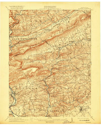
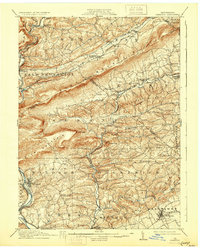
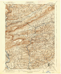
Editions of this 1911 Hamburg Map
5 editions found

Other maps of this area

1889 · Hazleton
USGS Topo · 1:62,500

1889 · Pottsville
USGS Topo · 1:62,500

1891 · Hazleton
USGS Topo · 1:62,500

1891 · Pottsville
USGS Topo · 1:62,500

1892 · Mahanoy
USGS Topo · 1:62,500

1893 · Hazleton
USGS Topo · 1:62,500

1893 · Mahanoy
USGS Topo · 1:62,500

1894 · Reading
USGS Topo · 1:62,500

1902 · Boyertown
USGS Topo · 1:62,500

1902 · Wernersville
USGS Topo · 1:62,500