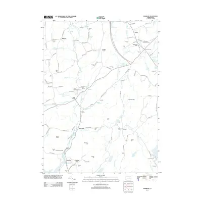
2012 Map of Hamburg
USGS Topo · Published 2012About this map
Eightmile River carves a deep valley through this corner of New London County, serving as the central axis for a series of historical hamlets and farmsteads. The settlement pattern here is distinctly nodal, with small crossroads such as North Lyme, Jewitt Corner, and Salem Four Corners anchored by family-named cemeteries and landmarks. To the north, Chapman Falls and the Devils Hopyard Field Airport mark a shift toward recreational and conservation land, while the southern reaches near Hamburg and Sterling City reveal a more concentrated residential and agricultural landscape. Numerous small family burial grounds, including the Whittlesey Cem and Morgan Cem, are scattered across the ridges, providing a tangible map for genealogists tracing the area's early families. The presence of the Yale Engineering Camp in the southeast adds a layer of educational history to a terrain dominated by names like Mount Archer and Wheatfield Ridge.
Find a feature on this map
141 named features on this map. Tap any name to fly to it.
Don’t see what you’re looking for? This feature index may not catch every label — zoom into the map to look around manually.
Map Details
Editions of this 2012 Hamburg Map
This is the sole edition of this map. No revisions or reprints were ever made.
Other maps of this area

1892 · New London
USGS Topo · 1:62,500

1892 · Norwich
USGS Topo · 1:62,500

1892 · Gilead
USGS Topo · 1:62,500

1893 · New London
USGS Topo · 1:62,500

1893 · Saybrook
USGS Topo · 1:62,500

1921 · New London
USGS Topo · 1:62,500

1934 · Niantic
USGS Topo · 1:24,000

1935 · Montville
USGS Topo · 1:24,000

1938 · Niantic
USGS Topo · 1:62,500

1939 · Montville
USGS Topo · 1:31,680