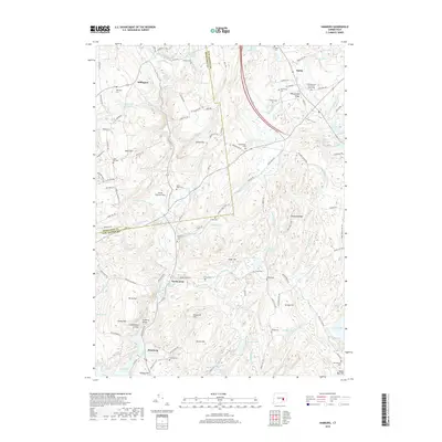
2018 Map of Hamburg
USGS Topo · Published 2018About this map
The Eightmile River and its numerous tributaries, including Burnhams Brook and Malt House Brook, define the drainage and settlement patterns of this southeastern Connecticut landscape. The village of Hamburg sits near the southern edge, where Hamburg Bridge crosses toward Hamburg Cove. This area preserves a high density of small family and community burial grounds, such as Sterling Cem, Pleasant View Cem, and Griffin Cem, reflecting a long history of local habitation. The terrain is characterized by named elevations like Nickerson Hill and Dolbia Hill, with Devils Hopyard Field in the north marking a significant open area near Millington. Transportation routes like the Norwich Essex Tpke and Salem Rd connect the scattered hamlets of North Lyme and Salem, while local industry and geography are noted at sites like Macks Mill Hill and Bond Reservoir.
Find a feature on this map
102 named features on this map. Tap any name to fly to it.
Don’t see what you’re looking for? This feature index may not catch every label — zoom into the map to look around manually.
Map Details
Editions of this 2018 Hamburg Map
This is the sole edition of this map. No revisions or reprints were ever made.
Other maps of this area

1892 · New London
USGS Topo · 1:62,500

1892 · Norwich
USGS Topo · 1:62,500

1892 · Gilead
USGS Topo · 1:62,500

1893 · New London
USGS Topo · 1:62,500

1893 · Saybrook
USGS Topo · 1:62,500

1921 · New London
USGS Topo · 1:62,500

1934 · Niantic
USGS Topo · 1:24,000

1935 · Montville
USGS Topo · 1:24,000

1938 · Niantic
USGS Topo · 1:62,500

1939 · Montville
USGS Topo · 1:31,680