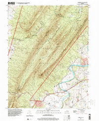
1997 Map of Hamburg
USGS Topo · Published 2000About this map
Massanutten Mountain dominates this landscape, its steep parallel ridges and deep gaps defining the physical boundaries between Shenandoah and Page counties. The topographic relief is marked by high points such as Strickler Knob and Duncan Knob, which overlook the winding course of the South Fork Shenandoah River as it meanders through the valley floor. Settlement is concentrated along the riverbanks and mountain base, where historic crossings like Whitehouse Landing and small communities such as Hamburg and Leaksville are situated. The presence of Furnace Cem near the northern edge suggests the area's earlier industrial ties, while the Camp Roosevelt Recreation Area points to the long-standing recreational use of the George Washington National Forest. Transportation patterns are dictated by the terrain, with roads concentrated in the flat lands near the Luray Caverns Airport or threading through natural passes like New Market Gap.
Find a feature on this map
44 named features on this map. Tap any name to fly to it.
Don’t see what you’re looking for? This feature index may not catch every label — zoom into the map to look around manually.
Map Details
Editions of this 1997 Hamburg Map
This is the sole edition of this map. No revisions or reprints were ever made.
Other maps of this area

1892 · Woodstock
USGS Topo · 1:125,000

1893 · Luray
USGS Topo · 1:125,000

1905 · Luray
USGS Topo · 1:125,000

1923 · Edinburg
USGS Topo · 1:62,500

1929 · Stony Man
USGS Topo · 1:48,000

1933 · Stony Man
USGS Topo · 1:62,500

1942 · Mt Jackson
USGS Topo · 1:62,500

1946 · Mt Jackson
USGS Topo · 1:62,500

1947 · Mt Jackson
USGS Topo · 1:62,500

1947 · Strasburg
USGS Topo · 1:62,500