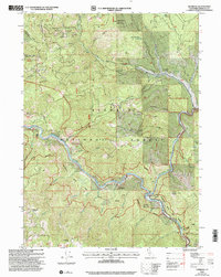
2001 Map of Hamburg
USGS Topo · Published 2004About this map
Klamath National Forest terrain dominates this survey of the Klamath River corridor in Siskiyou County, where the river carves a deep path through the mountains. The small settlement of Hamburg sits at the confluence where Horse Creek enters the main river, serving as a primary point of interest for local history. The map records several active and historical mineral interests, including Lucky Mine and various unnamed mines and prospects scattered across the steep ridges. Cultural and administrative landmarks like the Horse Creek Cemetery, the Steelhead Ranger Station, and Oak Knoll Scott River provide critical geographic anchors for genealogists and researchers tracing the 20th-century development of this remote canyon. High points such as Johnny O'Neil Ridge and White Cloud Mountain frame the landscape, illustrating the topographical challenges of early settlement and resource extraction in the region.
Find a feature on this map
54 named features on this map. Tap any name to fly to it.
Don’t see what you’re looking for? This feature index may not catch every label — zoom into the map to look around manually.
Map Details
Editions of this 2001 Hamburg Map
This is the sole edition of this map. No revisions or reprints were ever made.
Other maps of this area

1886 · Shasta
USGS Topo · 1:250,000

1894 · Shasta
USGS Topo · 1:250,000

1914 · Seiad
USGS Topo · 1:125,000

1922 · Seiad
USGS Topo · 1:125,000

1932 · Yreka
USGS Topo · 1:96,000

1939 · Yreka
USGS Topo · 1:125,000

1948 · Weed
USGS Topo · 1:250,000

1950 · Weed
USGS Topo · 1:250,000

1955 · Seiad Valley
USGS Topo · 1:62,500

1955 · Condrey Mtn
USGS Topo · 1:62,500