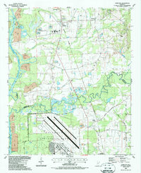
1987 Map of Hamilton
USGS Topo · Published 1987About this map
Columbus Air Force Base dominates the southern landscape of this 1980s survey, illustrating the significant military and aeronautical presence on the boundary of Lowndes and Monroe Counties. The terrain is defined by the winding course of the Buttahatchee River and the engineered waters of the Tennessee-Tombigbee Waterway (Columbus Lake), which includes several disposal areas and a Road on Levee. The map shows a region of transition where traditional agriculture and rural settlements like Hamilton and Kolola Springs coexist with active extraction industries, evidenced by numerous Gravel Pits and Gas Wells.
Find a feature on this map
45 named features on this map. Tap any name to fly to it.
Don’t see what you’re looking for? This feature index may not catch every label — zoom into the map to look around manually.
Map Details
Editions of this 1987 Hamilton Map
This is the sole edition of this map. No revisions or reprints were ever made.
Other maps of this area

1953 · West Point
USGS Topo · 1:250,000

1958 · West Point
USGS Topo · 1:250,000

1959 · West Point
USGS Topo · 1:62,500

1960 · Caledonia
USGS Topo · 1:62,500

1963 · West Point
USGS Topo · 1:250,000

1966 · Aberdeen
USGS Topo · 1:24,000

1966 · Amory SW
USGS Topo · 1:24,000

1966 · Amory SE
USGS Topo · 1:24,000

1982 · West Point
USGS Topo · 1:100,000

1984 · West Point
USGS Topo · 1:250,000