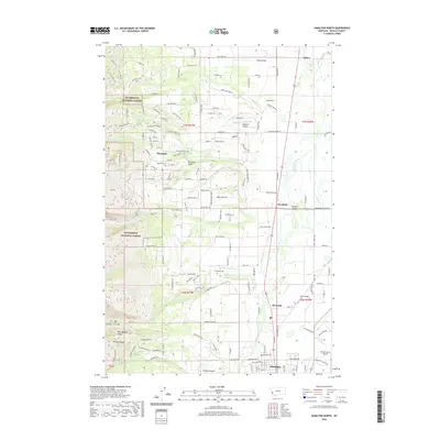
2020 Map of Hamilton North
USGS Topo · Published 2020About this map
Pinesdale and its surrounding communities are positioned where the rugged eastern slopes of the Bitterroot National Forest meet the fertile valley floor of the Bitterroot River. This 2020 topographic record shows a landscape defined by the transition from steep, timbered ridges like Romney Ridge and landmarks such as Don Mackey Point to the structured agricultural and residential grids of the valley. Water management and drainage are central to the area's layout, with numerous creeks including Sheafman Cr, Mill Cr, and Blodgett Cr flowing eastward toward the main river channel. Local history is anchored by sites like Pinesdale Cem and Blodgett Cem, while the region's aviation needs are served by a network of small landing strips including Hedditch Airport, Kimp Airport, and the larger Ravalli County Airport. The settlement patterns of Woodside and Riverside reflect the ongoing development along the valley corridor.
Find a feature on this map
89 named features on this map. Tap any name to fly to it.
Don’t see what you’re looking for? This feature index may not catch every label — zoom into the map to look around manually.
Map Details
Editions of this 2020 Hamilton North Map
This is the sole edition of this map. No revisions or reprints were ever made.
Other maps of this area

1901 · Hamilton
USGS Topo · 1:125,000

1956 · Hamilton
USGS Topo · 1:250,000

1959 · Hamilton
USGS Topo · 1:250,000

1960 · Hamilton
USGS Topo · 1:250,000

1964 · Hamilton
USGS Topo · 1:250,000

1964 · Hamilton South
USGS Topo · 1:24,000

1964 · Ward Mountain
USGS Topo · 1:24,000
1964 · Mountain House
USGS Topo · 1:24,000
1966 · Printz Ridge
USGS Topo · 1:24,000
1966 · Gash Point
USGS Topo · 1:24,000