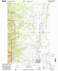
1998 Map of Hamilton North
USGS Topo · Published 2002About this map
The Bitterroot River valley floor transitions into the steep eastern slopes of the Bitterroot Range, where the Bitterroot National Forest begins. Near the southern edge of this 1990s-era survey, the city of Hamilton is shown with its grid and infrastructure, including the County Fairground and Hamilton Airport. To the north of town, the Daly Mansion stands near the Republican Ditch, a testament to the early development of the Bitterroot Valley. Water management is a defining characteristic of the landscape, evidenced by the Supply Ditch, Corvallis Canal, and several gaging stations along mountain outflows like Blodgett Creek. Higher in the canyon, the Blodgett Creek Trailhead and Blodgett Canyon Campground provide access to the rugged interior, while smaller communities like Pinesdale and Woodside sit along the foothills and the riverbank.
Find a feature on this map
43 named features on this map. Tap any name to fly to it.
Don’t see what you’re looking for? This feature index may not catch every label — zoom into the map to look around manually.
Map Details
Editions of this 1998 Hamilton North Map
This is the sole edition of this map. No revisions or reprints were ever made.
Other maps of this area

1901 · Hamilton
USGS Topo · 1:125,000

1956 · Hamilton
USGS Topo · 1:250,000

1959 · Hamilton
USGS Topo · 1:250,000

1960 · Hamilton
USGS Topo · 1:250,000

1964 · Hamilton
USGS Topo · 1:250,000

1964 · Hamilton South
USGS Topo · 1:24,000

1964 · Ward Mountain
USGS Topo · 1:24,000
1964 · Mountain House
USGS Topo · 1:24,000
1966 · Printz Ridge
USGS Topo · 1:24,000
1966 · Gash Point
USGS Topo · 1:24,000