Loading...
Loading map...1956 Map of Hamilton
USGS Topo · Published 1976About this map
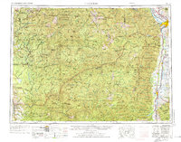
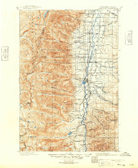
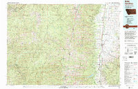
The Bitterroot Valley serves as the primary corridor for settlement and transit along the eastern edge of this mid-century survey. Towns such as Hamilton, Stevensville, Victor, and Corvallis cluster along the Bitterroot River, supported by the Northern Pacific railroad line. To the west, the landscape rises sharply into the Bitterroot Mountains and the Clearwater Mountains, a region dominated by massive timber holdings within the Clearwater National Forest and Selway Bitterroot Wilderness Area.
Find a feature on this map
76 named features on this map. Tap any name to fly to it.
Don’t see what you’re looking for? This feature index may not catch every label — zoom into the map to look around manually.
Map Details
Date Portrayed1956
Date Published1976
PublisherU.S. Geological Survey
Map TypeTopographic
Scale1:250,000
Physical Dimensions28.1 x 22 inches
Editions of this 1956 Hamilton Map
2 editions found

Historical Maps of Missoula Through Time
6 maps found


Featured Locations
Source Details
SourceU.S. Geological Survey
CopyrightPublic Domain