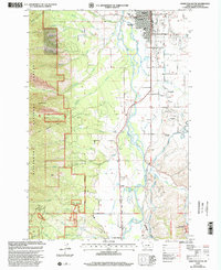
1998 Map of Hamilton South
USGS Topo · Published 2002About this map
The Bitterroot River valley south of Hamilton is defined by a complex network of water management systems and educational institutions at the close of the 20th century. The map illustrates the intensive irrigation required for the region's development, featuring the Republican Ditch, Hedge Ditch, and Grantsdale Canal cutting through the landscape toward settlements like Grantsdale and Charlos Heights. To the west, the terrain rises sharply into the Bitterroot National Forest, where the Ward Mountain Trail leads toward Goat Mountain.
Find a feature on this map
59 named features on this map. Tap any name to fly to it.
Don’t see what you’re looking for? This feature index may not catch every label — zoom into the map to look around manually.
Map Details
Editions of this 1998 Hamilton South Map
This is the sole edition of this map. No revisions or reprints were ever made.
Other maps of this area

1901 · Hamilton
USGS Topo · 1:125,000

1956 · Hamilton
USGS Topo · 1:250,000

1959 · Hamilton
USGS Topo · 1:250,000

1960 · Hamilton
USGS Topo · 1:250,000

1964 · Hamilton
USGS Topo · 1:250,000

1964 · Hamilton South
USGS Topo · 1:24,000

1964 · Darby
USGS Topo · 1:24,000

1964 · Ward Mountain
USGS Topo · 1:24,000
1964 · Como Peaks
USGS Topo · 1:24,000
1964 · Deer Mountain
USGS Topo · 1:24,000
Featured Places
- Hamilton, MT
- Grantsdale, MT
- Big Sky Mobile Home Park, MT
- Charlos Heights, MT
- Hamilton Mobile Home Park, MT