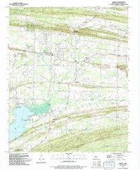
1994 Map of Hamlet
USGS Topo · Published 1994About this map
Cadron Ridge and the southern slopes of Wilson Hill define the topography of this Faulkner County landscape in the mid-1990s. The settlement of Hamlet sits centrally, surrounded by a dense network of country churches including Friendship Ch, Liberty Ch, and the Old Liberty Ch. These spiritual centers, paired with burial grounds like the New Liberty Cem and Crestlawn Mem Park, provide a clear picture of the area's rural social fabric. To the southwest, the waters of Conway Lake meet the Camp Robinson State Wildlife Management Area, where specialized access points like Palarm Creek Landing and Art Pond Landing mark the edge of the preserve. The presence of several Shale Pits and a Quarry indicates the local importance of stone extraction alongside the agricultural use of the drainage basins formed by Little Palarm Creek and Cypress Creek.
Find a feature on this map
37 named features on this map. Tap any name to fly to it.
Don’t see what you’re looking for? This feature index may not catch every label — zoom into the map to look around manually.
Map Details
Editions of this 1994 Hamlet Map
This is the sole edition of this map. No revisions or reprints were ever made.
Other maps of this area

1891 · Little Rock
USGS Topo · 1:125,000

1893 · Little Rock
USGS Topo · 1:125,000

1941 · Olmstead
USGS Topo · 1:31,680

1953 · Cato
USGS Topo · 1:24,000

1953 · Mayflower
USGS Topo · 1:24,000

1954 · Olmstead
USGS Topo · 1:24,000

1955 · Little Rock
USGS Topo · 1:250,000

1956 · Little Rock
USGS Topo · 1:250,000

1956 · Russellville
USGS Topo · 1:250,000

1960 · Little Rock
USGS Topo · 1:250,000