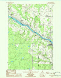
1986 Map of Hamlin
USGS Topo · Published 1986About this map
The ST John River forms the international boundary in this northern Maine landscape, serving as the central axis for a cross-border network of rural sidings and small settlements in the 1980s. On the American side, the Hamlin township and Caswell Plantation contain a series of family-named water features and small brooks, including Willard Brook, Boney Brook, and Lavoie Brook. The topographic detail shows the scattered development near Bellefleur Station and Poitras Siding, likely tied to the timber or agricultural transport along the river corridor.
Find a feature on this map
35 named features on this map. Tap any name to fly to it.
Don’t see what you’re looking for? This feature index may not catch every label — zoom into the map to look around manually.
Map Details
Editions of this 1986 Hamlin Map
This is the sole edition of this map. No revisions or reprints were ever made.
Other maps of this area

1921 · Van Buren
USGS Topo · 1:250,000

1930 · Fort Fairfield
USGS Topo · 1:48,000

1931 · Van Buren
USGS Topo · 1:48,000

1933 · Fort Fairfield
USGS Topo · 1:62,500

1934 · Van Buren
USGS Topo · 1:62,500

1951 · Van Buren
USGS Topo · 1:62,500

1951 · Fort Fairfield
USGS Topo · 1:62,500

1953 · Fort Fairfield NW
USGS Topo · 1:24,000
1953 · Limestone
USGS Topo · 1:24,000

1959 · Woodstock
USGS Topo · 1:250,000