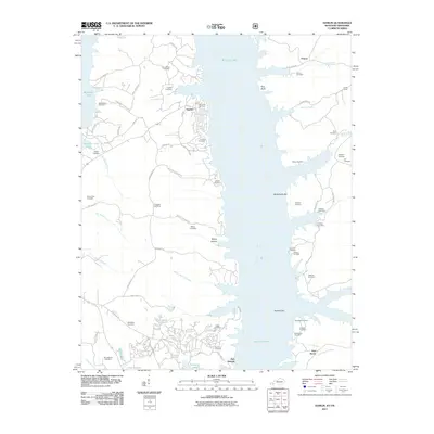
2011 Map of Hamlin
USGS Topo · Published 2011About this map
Fort Heiman and the site of Fort Henry anchor this survey of the riverbanks where Kentucky and Tennessee meet. The landscape is dominated by the broad expanse of Kentucky Lake, which submerged much of the original river bottomland. Along its western shore, the settlement of Hamlin sits between Boyds Branch and Blood River, surrounded by a dense concentration of family burial grounds such as Oak Level Cemetery, Kimbro Cemetery, and Winchester Cemetery. On the eastern shore, the terrain rises toward Pine Bluff and the waters of Tischel Creek. This area preserves a legacy of early river navigation and strategic positions, visible in features like McCullochs Bar and Panther Bar. Genealogists will find a high density of rural cemeteries, including McCuiston Cemetery and Shackleford Cemetery, reflecting the deep-rooted family ties in this region of Calloway County.
Find a feature on this map
72 named features on this map. Tap any name to fly to it.
Don’t see what you’re looking for? This feature index may not catch every label — zoom into the map to look around manually.
Map Details
Editions of this 2011 Hamlin Map
This is the sole edition of this map. No revisions or reprints were ever made.
Other maps of this area

1936 · Buchanan
USGS Topo · 1:24,000

1936 · Tharpe
USGS Topo · 1:24,000

1936 · New Concord
USGS Topo · 1:24,000

1936 · Hamlin
USGS Topo · 1:24,000

1936 · Centerville Landing
USGS Topo · 1:24,000

1936 · Rushing
USGS Topo · 1:24,000

1936 · Standing Rock
USGS Topo · 1:24,000

1936 · Hico
USGS Topo · 1:24,000

1942 · New Concord
USGS Topo · 1:24,000

1942 · Hico
USGS Topo · 1:24,000