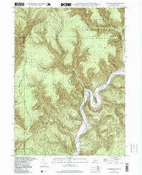
1994 Map of Hammersley Fork
USGS Topo · Published 1999About this map
Kettle Creek defines the valley floor of this northern Pennsylvania landscape, where the settlements of Hammersley Fork and Leidy are established along its winding course. The topography is dominated by the steep ridges of the Pennsylvania Wilds, with significant tracts of land managed as the Susquehannock State Forest and Sproul State Forest. A dramatic horseshoe loop at Oxbow Bend highlights the creek's erosive power through the plateau, while the southern portion of the map includes the recreation areas of Kettle Creek State Park. Local history is anchored by markers of early community life, such as the Central Sch and the Summerson Cem. Numerous named hollows and branches, including Tate Hollow and Wykoff Branch, detail the complex drainage system that feeds the main waterway, reflecting the timber and wilderness heritage of Clinton County.
Find a feature on this map
64 named features on this map. Tap any name to fly to it.
Don’t see what you’re looking for? This feature index may not catch every label — zoom into the map to look around manually.
Map Details
Editions of this 1994 Hammersley Fork Map
This is the sole edition of this map. No revisions or reprints were ever made.
Other maps of this area

1945 · Driftwood
USGS Topo · 1:48,000

1945 · First Fork
USGS Topo · 1:24,000

1945 · Sinnemahoning
USGS Topo · 1:24,000

1946 · Renovo West
USGS Topo · 1:62,500

1946 · Hammersley Fork
USGS Topo · 1:24,000

1946 · Keating
USGS Topo · 1:24,000

1946 · Tamarack
USGS Topo · 1:24,000

1946 · Renovo West
USGS Topo · 1:24,000

1947 · First Fork
USGS Topo · 1:24,000

1947 · Sinnemahoning
USGS Topo · 1:24,000
Featured Places
- Leidy Township, PA
- Wharton Township, PA
- East Keating Township, PA
- Grove Township, PA
- Hammersley Fork, Leidy Township