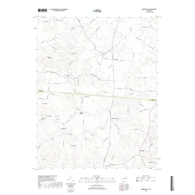
2019 Map of Hammonville
USGS Topo · Published 2019About this map
The boundary between Larue Co and Hart Co divides this landscape of central Kentucky, where small rural communities are connected by a network of winding roads and named hollows. In the northern section, the settlement of Maxine sits near the headwaters of Tucker Creek, while the village of Hammonville serves as a central hub near the crossing of Bacon Creek. The terrain is defined by prominent elevations such as Three Springs Knob and Veach Knob, interspersed with low-lying areas like Barefoot Hollow. For genealogical research, the map identifies local burial grounds including McCanless Cemetery and Gaddie Cemetery, alongside long-established residential clusters at Wabash, Jonesville, and Talley. This documentation of the area's rural road network, from Upton Talley Rd to Knob School House Rd, illustrates the persistent settlement patterns of these agricultural communities.
Find a feature on this map
72 named features on this map. Tap any name to fly to it.
Don’t see what you’re looking for? This feature index may not catch every label — zoom into the map to look around manually.
Map Details
Editions of this 2019 Hammonville Map
This is the sole edition of this map. No revisions or reprints were ever made.
Other maps of this area

1934 · Munfordville
USGS Topo · 1:48,000

1935 · Elizabethtown
USGS Topo · 1:48,000

1937 · Munfordville
USGS Topo · 1:62,500

1938 · Elizabethtown
USGS Topo · 1:62,500

1949 · Sonora
USGS Topo · 1:24,000

1949 · Tonieville
USGS Topo · 1:24,000
1949 · Elizabethtown
USGS Topo · 1:62,500

1953 · Hudgins
USGS Topo · 1:24,000

1953 · Munfordville
USGS Topo · 1:24,000

1953 · Magnolia
USGS Topo · 1:24,000