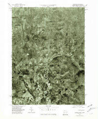
1975 Map of Hampden
USGS Topo · Published 1981About this map
The Wilbraham Mountains dominate the eastern landscape of this 1975 orthophotoquad, a specialized photographic survey that captures the transitional landscape between the Connecticut River Valley and the higher terrain to the east. Unlike traditional topographic maps, this aerial imagery provides a direct look at the 1970s land-use patterns, showing the precise density of forest cover against the expanding residential and agricultural footprints of Hampden and the eastern edge of Springfield.
Find a feature on this map
6 named features on this map. Tap any name to fly to it.
Don’t see what you’re looking for? This feature index may not catch every label — zoom into the map to look around manually.
Map Details
Editions of this 1975 Hampden Map
This is the sole edition of this map. No revisions or reprints were ever made.
Other maps of this area

1886 · Springfield
USGS Topo · 1:62,500

1887 · Palmer
USGS Topo · 1:62,500

1889 · Springfield
USGS Topo · 1:62,500

1889 · Palmer
USGS Topo · 1:62,500

1892 · Hartford
USGS Topo · 1:62,500

1892 · Tolland
USGS Topo · 1:62,500

1893 · Springfield
USGS Topo · 1:62,500

1893 · Palmer
USGS Topo · 1:62,500

1895 · Springfield
USGS Topo · 1:62,500

1896 · Holyoke
USGS Topo · 1:125,000