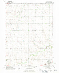
1968 Map of Hampton
USGS Topo · Published 1971About this map
The town of Hampton serves as the focal point of this 1960s agricultural landscape, situated along the C B & Q railroad tracks in Hamilton County. The map details a highly organized section-line grid typical of the Nebraska plains, punctuated by small rural landmarks that provide essential context for local genealogists. Evidence of community life is visible through several burial sites including Salem Cem, United Cem, and Lincoln Valley Cem, alongside religious centers such as St Johns Ch. To the northwest, the Marquette-Carlson Airport marks the influence of aviation on this rural corridor. The hydrology of the region is defined by the winding paths of the Big Blue River and Lincoln Creek, which cut through the townships of Otis, Grant, and Valley, providing a contrast to the otherwise flat, well-dotted terrain defined by numerous groundwater access points.
Find a feature on this map
16 named features on this map. Tap any name to fly to it.
Don’t see what you’re looking for? This feature index may not catch every label — zoom into the map to look around manually.
Map Details
Editions of this 1968 Hampton Map
This is the sole edition of this map. No revisions or reprints were ever made.
Other maps of this area

1896 · Stromsburg
USGS Topo · 1:125,000

1898 · York
USGS Topo · 1:125,000

1898 · Grand Island
USGS Topo · 1:125,000

1899 · St. Paul
USGS Topo · 1:125,000

1899 · York
USGS Topo · 1:125,000

1955 · Broken Bow
USGS Topo · 1:250,000

1955 · Fremont
USGS Topo · 1:250,000

1955 · Lincoln
USGS Topo · 1:250,000

1955 · Grand Island
USGS Topo · 1:250,000

1956 · Broken Bow
USGS Topo · 1:250,000