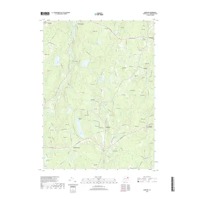
2018 Map of Hampton
USGS Topo · Published 2018About this map
The Natchaug River and Little River carve through a landscape of prominent ridges and historic cemeteries in this part of northeastern Connecticut. Rural settlements like Hampton, Phoenixville, and Rawson anchor the region, connected by long-standing routes such as the Hartford Tpke and Providence Tpke. Genealogists will find a high density of burial grounds, including the Old Ashford Cem, Abington Cem, and Litchfield Cem, reflecting the early village centers of these hill towns. The presence of Pine Acres Lake and the Hampton Reservoir highlights the importance of water management in this terrain, while the Natchaug State Forest provides a preserved look at the woodland character that has long defined the area. The map illustrates a settled upland economy where family names are often preserved in landmarks like Trowbridge Hill, Sharpe Hill, and Allen Hill.
Find a feature on this map
146 named features on this map. Tap any name to fly to it.
Don’t see what you’re looking for? This feature index may not catch every label — zoom into the map to look around manually.
Map Details
Editions of this 2018 Hampton Map
This is the sole edition of this map. No revisions or reprints were ever made.
Other maps of this area

1889 · Putnam
USGS Topo · 1:62,500

1889 · Moosup
USGS Topo · 1:62,500

1892 · Woodstock
USGS Topo · 1:62,500

1892 · Norwich
USGS Topo · 1:62,500

1893 · Putnam
USGS Topo · 1:62,500

1893 · Moosup
USGS Topo · 1:62,500

1919 · Putnam
USGS Topo · 1:62,500

1920 · Moosup
USGS Topo · 1:62,500

1921 · Woodstock
USGS Topo · 1:62,500

1943 · Plainfield
USGS Topo · 1:31,680