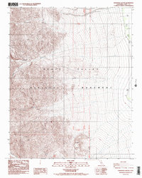
1987 Map of Hanaupah Canyon
USGS Topo · Published 1988About this map
Death Valley National Monument reveals a stark landscape where extreme relief meets the valley floor, documented here in the late 1980s. The drainage system of Hanaupah Canyon and its South Fork carve through the western mountains, leading toward the basin where water sources like Shortys Well and Tule Spring provided critical stops for travelers and early inhabitants. Evidence of early mineral interest remains through several identified Prospects located near the southern boundary of the quadrangle. The topography transitions from the high elevations of Chuckwalla Canyon down to the below-sea-level flats of the valley, while a network of 4wd tracks provides the only access into the remote reaches of Starvation Canyon.
Find a feature on this map
15 named features on this map. Tap any name to fly to it.
Don’t see what you’re looking for? This feature index may not catch every label — zoom into the map to look around manually.
Map Details
Editions of this 1987 Hanaupah Canyon Map
2 editions found
Other maps of this area

1908 · Furnace Creek
USGS Topo · 1:250,000

1908 · Ballarat
USGS Topo · 1:250,000

1910 · Furnace Creek
USGS Topo · 1:250,000

1913 · Ballarat
USGS Topo · 1:250,000

1948 · Death Valley
USGS Topo · 1:250,000

1952 · Furnace Creek
USGS Topo · 1:62,500

1952 · Bennetts Well
USGS Topo · 1:62,500

1952 · Telescope Peak
USGS Topo · 1:62,500

1952 · Emigrant Canyon
USGS Topo · 1:62,500

1954 · Death Valley
USGS Topo · 1:250,000