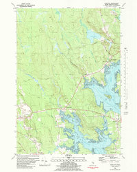
1981 Map of Hancock
USGS Topo · Published 1982About this map
The coastal transition of Hancock County is defined by the intricate intersection of the Skillings River and the sweeping tidal flats of Taunton Bay. In the early 1980s, the landscape reflected a mix of maritime geography and industrial utility, with numerous gravel pits and a quarry located near Abbott Cem. The Maine Central Railroad cuts across the terrain, passing through the settlement of Egypt and following a defined railroad grade toward the eastern shore. Small coastal communities like West Franklin and South Hancock anchor the shoreline, where landmarks such as the Hancock Sch and Riverside Cem serve as focal points for local history. The map also reveals the complex hydrography of the region, from the inland waters of Great Pond to the saltwater reaches of Kilkenny Cove and Egypt Bay.
Find a feature on this map
59 named features on this map. Tap any name to fly to it.
Don’t see what you’re looking for? This feature index may not catch every label — zoom into the map to look around manually.
Map Details
Editions of this 1981 Hancock Map
This is the sole edition of this map. No revisions or reprints were ever made.
Other maps of this area

1904 · Mount Desert
USGS Topo · 1:62,500

1904 · Bar Harbor
USGS Topo · 1:62,500

1911 · Ellsworth
USGS Topo · 1:62,500

1930 · Tunk Lake
USGS Topo · 1:48,000

1932 · Tunk Lake
USGS Topo · 1:62,500

1940 · Ellsworth
USGS Topo · 1:62,500

1942 · Bar Harbor
USGS Topo · 1:62,500

1942 · Ellsworth
USGS Topo · 1:62,500

1942 · Mount Desert
USGS Topo · 1:62,500

1942 · Tunk Lake
USGS Topo · 1:62,500