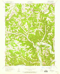
1954 Map of Hancock
USGS Topo · Published 1955About this map
The St Louis San Francisco railroad cuts a vital path through this mid-1950s landscape, connecting the small settlements of Hancock and Helm along the northern heights. This area is characterized by the winding descent toward the Gasconade River, where the terrain drops sharply at Yellow Bluff. The mapping records a rural community heavily reliant on local institutions, evidenced by the dense distribution of country schools and churches. Many families can trace their local roots through the numerous burial grounds scattered across the townships of Tavern, Union, and Cullen, including the Teeple Cemetery and Lipscomb Cemetery. The transition of the local economy is visible in the presence of Wheeler Mill near the riverbanks and the Hamilton School (abandoned), signaling shifts in the educational and industrial landscape of rural Pulaski County.
Find a feature on this map
33 named features on this map. Tap any name to fly to it.
Don’t see what you’re looking for? This feature index may not catch every label — zoom into the map to look around manually.
Map Details
Editions of this 1954 Hancock Map
2 editions found
Other maps of this area

1888 · Tuscumbia
USGS Topo · 1:125,000

1894 · Tuscumbia
USGS Topo · 1:125,000

1933 · Iberia
USGS Topo · 1:62,500

1936 · Waynesville
USGS Topo · 1:48,000

1937 · Iberia
USGS Topo · 1:62,500

1942 · Waynesville
USGS Topo · 1:62,500

1943 · Richland
USGS Topo · 1:62,500

1944 · Waynesville
USGS Topo · 1:62,500

1947 · Jefferson City
USGS Topo · 1:250,000

1948 · Tavern
USGS Topo · 1:62,500