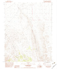
1983 Map of Hancock Summit
USGS Topo · Published 1983About this map
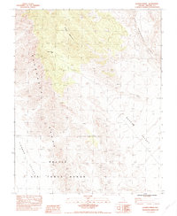
Hancock Summit provides the namesake high point for this 1983 topographic study of the Pahranagat Range in eastern Nevada. The landscape is defined by high-desert terrain where infrastructure is sparse, limited primarily to a Single Pole Wooden Powerline traversing the northern flats and a Borrow Pit indicating local excavation activity. A Gaging Station located near the northern edge suggests the monitoring of intermittent water flow in an otherwise arid environment. This provisional map captures the transition between the valley floor and the ascending mountain slopes, marking the historical footprint of the Ash Springs 1848 S cadastral survey point, an essential marker for early land management in Lincoln County.
Find a feature on this map
7 named features on this map. Tap any name to fly to it.
Don’t see what you’re looking for? This feature index may not catch every label — zoom into the map to look around manually.
Map Details
Editions of this 1983 Hancock Summit Map
This is the sole edition of this map. No revisions or reprints were ever made.
Other maps of this area

1945 · Alamo
USGS Topo · 1:125,000

1954 · Caliente
USGS Topo · 1:250,000

1959 · Caliente
USGS Topo · 1:250,000

1969 · Alamo
USGS Topo · 1:24,000

1969 · Ash Springs
USGS Topo · 1:24,000

1970 · Hiko
USGS Topo · 1:24,000
1980 · Alamo
USGS Topo · 1:24,000
1983 · Cutler Reservoir
USGS Topo · 1:24,000
1983 · Crescent Reservoir
USGS Topo · 1:24,000
1983 · Badger Spring
USGS Topo · 1:24,000