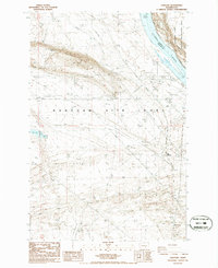
1986 Map of Hanford
USGS Topo · Published 1986About this map
The Hanford Site (DOE) dominates this mid-1980s landscape, reflecting the restricted industrial and scientific character of the high desert along the Columbia River. While the former townsite of Hanford is marked, the surrounding terrain is heavily modified by the infrastructure of the Department of Energy, including a Radio Facility, numerous Borrow Pits, and a Sanitary Disposal Site. Across the river, the Wahluke Slope Habitat Management Area and the Wahluke Slope provide a stark contrast in land use, showing the protected natural environment adjacent to the atomic-era facilities. The presence of May Junction and several transmission lines tracing through the Gable Mountains further illustrates the complex utility and rail networks required to maintain this high-security installation during the late Cold War period.
Find a feature on this map
12 named features on this map. Tap any name to fly to it.
Don’t see what you’re looking for? This feature index may not catch every label — zoom into the map to look around manually.
Map Details
Editions of this 1986 Hanford Map
This is the sole edition of this map. No revisions or reprints were ever made.
Other maps of this area

1915 · Prosser
USGS Topo · 1:125,000

1916 · Coyote Rapids
USGS Topo · 1:62,500

1917 · Pasco
USGS Topo · 1:125,000

1917 · Prosser
USGS Topo · 1:125,000

1924 · Hanford
USGS Topo · 1:62,500

1951 · Richland
USGS Topo · 1:62,500

1951 · Hanford
USGS Topo · 1:62,500

1951 · Corral Canyon
USGS Topo · 1:62,500

1951 · Coyote Rapids
USGS Topo · 1:62,500

1953 · Walla Walla
USGS Topo · 1:250,000