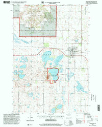
1998 Map of Hankinson
USGS Topo · Published 2000About this map
Hankinson serves as the regional hub for this part of Richland County, situated at a junction of the Soo Line railroad during the late twentieth century. The landscape is defined by its glacial prairie potholes and wetlands, notably the Lake Elsie National Wildlife Refuge and the southern reaches of the Sheyenne National Grassland. These protected areas surround a network of named water bodies, including Willard Lake, Grass Lake, and Horseshoe Lake.
Find a feature on this map
32 named features on this map. Tap any name to fly to it.
Don’t see what you’re looking for? This feature index may not catch every label — zoom into the map to look around manually.
Map Details
Editions of this 1998 Hankinson Map
This is the sole edition of this map. No revisions or reprints were ever made.
Other maps of this area

1904 · Wahpeton
USGS Topo · 1:125,000

1907 · Wyndmere
USGS Topo · 1:125,000

1917 · New Effington
USGS Topo · 1:62,500

1953 · Milbank
USGS Topo · 1:250,000

1953 · Fargo
USGS Topo · 1:250,000

1956 · Fargo
USGS Topo · 1:250,000

1958 · Milbank
USGS Topo · 1:250,000

1964 · Hankinson
USGS Topo · 1:24,000

1964 · Mantador
USGS Topo · 1:24,000

1964 · Moselle
USGS Topo · 1:24,000