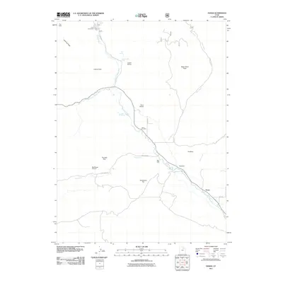
2011 Map of Hanna
USGS Topo · Published 2011About this map
Hanna serves as the primary settlement hub in this Duchesne County landscape, situated where the Duchesne River meets the local road network. The presence of the Hanna Post Office marks the community center, while the surrounding terrain is defined by a complex system of drainages and landmarks. Significant water features like the West Fork Duchesne River and Blind Stream carve through the topography, which is punctuated by descriptively named features such as The Hens Nest, Big Rough Canyon, and Dutchmans Flat.
Find a feature on this map
27 named features on this map. Tap any name to fly to it.
Don’t see what you’re looking for? This feature index may not catch every label — zoom into the map to look around manually.
Map Details
Editions of this 2011 Hanna Map
This is the sole edition of this map. No revisions or reprints were ever made.
Other maps of this area

1885 · Uinta
USGS Topo · 1:250,000

1901 · Hayden Peak
USGS Topo · 1:125,000

1903 · Hayden Peak
USGS Topo · 1:125,000

1954 · Salt Lake City
USGS Topo · 1:250,000

1958 · Salt Lake City
USGS Topo · 1:250,000

1960 · Salt Lake City
USGS Topo · 1:250,000
1962 · Wolf Creek
USGS Topo · 1:24,000

1962 · Hanna
USGS Topo · 1:24,000

1962 · Tabiona
USGS Topo · 1:24,000

1962 · Raspberry Knoll
USGS Topo · 1:24,000