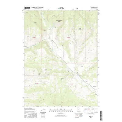
2017 Map of Hanna
USGS Topo · Published 2017About this map
The settlement of Hanna sits at the confluence of several vital water routes in the Uinta Valley, where the Duchesne River meets the man-made irrigation infrastructure of the Rhoades Canal and Farm Cr Canal. This 2017 survey details a landscape defined by sharp elevation shifts between the high plateaus of the Ashley National Forest and the agricultural valley floor. To the north, the terrain rises toward Wagon Road Ridge and Lightning Ridge, while the river system is fed by numerous named sources like Warm Springs and Jackass Parson Spring. The map documents a network of rural routes including Sandcreek Rd and Tabby Swale Rd, which connect isolated points of interest such as The Hens Nest and Dutchmans Flat. The presence of Tabby Mtn and Tabby Swale to the south underscores the geographical naming conventions tied to this portion of Duchesne County.
Find a feature on this map
37 named features on this map. Tap any name to fly to it.
Don’t see what you’re looking for? This feature index may not catch every label — zoom into the map to look around manually.
Map Details
Editions of this 2017 Hanna Map
This is the sole edition of this map. No revisions or reprints were ever made.
Other maps of this area

1885 · Uinta
USGS Topo · 1:250,000

1901 · Hayden Peak
USGS Topo · 1:125,000

1903 · Hayden Peak
USGS Topo · 1:125,000

1954 · Salt Lake City
USGS Topo · 1:250,000

1958 · Salt Lake City
USGS Topo · 1:250,000

1960 · Salt Lake City
USGS Topo · 1:250,000
1962 · Wolf Creek
USGS Topo · 1:24,000

1962 · Hanna
USGS Topo · 1:24,000

1962 · Tabiona
USGS Topo · 1:24,000

1962 · Raspberry Knoll
USGS Topo · 1:24,000