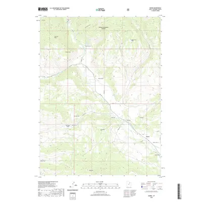
2020 Map of Hanna
USGS Topo · Published 2020About this map
The Hanna settlement sits at a confluence of geography and water management in Duchesne County, where the Duchesne River meets irrigation infrastructure like the Rhoades Canal and Farm Cr Canal. This landscape, much of which is contained within the Ashley National Forest, is defined by its dramatic relief, moving from the depths of The Hole and Larsen Hollow to the heights of Lightning Ridge and Tabby Mtn. The presence of Warm Springs and several smaller water sources, including Big Spring and Jackass Parson Spring, highlights the critical role of water in this high-country environment. Local orientation centers on distinct landforms like The Mesa, The Point, and The Hens Nest, providing a detailed look at the rural topography of the Uinta Valley.
Find a feature on this map
34 named features on this map. Tap any name to fly to it.
Don’t see what you’re looking for? This feature index may not catch every label — zoom into the map to look around manually.
Map Details
Editions of this 2020 Hanna Map
This is the sole edition of this map. No revisions or reprints were ever made.
Other maps of this area

1885 · Uinta
USGS Topo · 1:250,000

1901 · Hayden Peak
USGS Topo · 1:125,000

1903 · Hayden Peak
USGS Topo · 1:125,000

1954 · Salt Lake City
USGS Topo · 1:250,000

1958 · Salt Lake City
USGS Topo · 1:250,000

1960 · Salt Lake City
USGS Topo · 1:250,000
1962 · Wolf Creek
USGS Topo · 1:24,000

1962 · Hanna
USGS Topo · 1:24,000

1962 · Tabiona
USGS Topo · 1:24,000

1962 · Raspberry Knoll
USGS Topo · 1:24,000