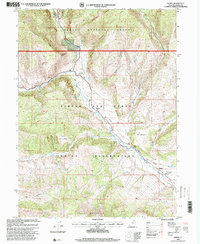
1996 Map of Hanna
USGS Topo · Published 2000About this map
The Duchesne River valley serves as a primary corridor through this high-elevation landscape, where the Ashley National Forest meets the Uintah and Ouray Indian Reservation. At the center of this geographic transition sits Hanna, a small mountain community supported by the Stockmore Ranger Station. The map illustrates a complex network of canyons and high ridges, including the prominent Tabby Mountain to the south and Lightning Ridge in the northwest. Water management is a visible priority in this arid mountain environment, evidenced by the Little Farm Creek Canal and various named springs like Larsen Spring. The rugged eastern slopes are marked by historical travel ways such as Wagon Road Ridge and unique natural landmarks like the Nature Arch, documenting the early infrastructure and recreational features of Duchesne County.
Find a feature on this map
32 named features on this map. Tap any name to fly to it.
Don’t see what you’re looking for? This feature index may not catch every label — zoom into the map to look around manually.
Map Details
Editions of this 1996 Hanna Map
This is the sole edition of this map. No revisions or reprints were ever made.
Other maps of this area

1885 · Uinta
USGS Topo · 1:250,000

1901 · Hayden Peak
USGS Topo · 1:125,000

1903 · Hayden Peak
USGS Topo · 1:125,000

1954 · Salt Lake City
USGS Topo · 1:250,000

1958 · Salt Lake City
USGS Topo · 1:250,000

1960 · Salt Lake City
USGS Topo · 1:250,000
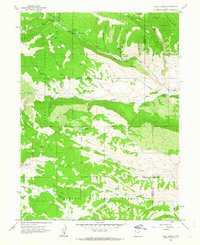
1962 · Wolf Creek
USGS Topo · 1:24,000

1962 · Hanna
USGS Topo · 1:24,000

1962 · Tabiona
USGS Topo · 1:24,000

1962 · Raspberry Knoll
USGS Topo · 1:24,000