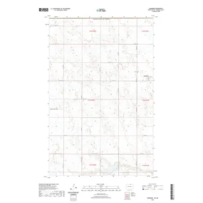
2020 Map of Hansboro
USGS Topo · Published 2020About this map
Hansboro sits at the northern edge of Towner County, positioned directly against the international boundary with the United States of America and Canada. This high-plains landscape is defined by the prairie potholes and small depressions characteristic of the region, punctuated by Hidden Island Coulee and the elongated waters of Armourdale Lake to the south. The settlement of Hansboro maintains a traditional grid centered on Main St and 3rd Ave, serving as a remote outpost in a vast agricultural territory. The grid of rural section roads, including Picton Rd and Cemetery Rd, facilitates movement between large tracts of farmland. Local history is anchored by the Hansboro Cem, located just north of the town site. This modern survey reflects the enduring spatial organization of North Dakota's borderlands, where the township and range system dictates the placement of every farmstead and thoroughfare.
Find a feature on this map
27 named features on this map. Tap any name to fly to it.
Don’t see what you’re looking for? This feature index may not catch every label — zoom into the map to look around manually.
Map Details
Editions of this 2020 Hansboro Map
This is the sole edition of this map. No revisions or reprints were ever made.
Other maps of this area

1953 · Devils Lake
USGS Topo · 1:250,000

1956 · Devils Lake
USGS Topo · 1:250,000
1969 · Hansboro NE
USGS Topo · 1:24,000
1969 · Hansboro
USGS Topo · 1:24,000

1969 · Rolla NE
USGS Topo · 1:24,000

1970 · Hansboro SW
USGS Topo · 1:24,000

1970 · Hansboro SE
USGS Topo · 1:24,000

1970 · Rolla
USGS Topo · 1:24,000

1985 · Rock Lake
USGS Topo · 1:100,000
2011 · Hansboro SW
USGS Topo · 1:24,000