Old Maps of Towner County, North Dakota
Explore 198 old maps of Towner County, spanning from 1953 to today. These high-resolution historic maps reveal how streets, neighborhoods, landmarks, and natural features evolved over time — perfect for genealogy, metal detecting, research, and local history exploration.
What you can do with these maps:
- See how Towner County changed over time: Compare historical maps to modern-day views to trace roads, homesites, rail lines & more.
- View detailed metadata: Each map includes creators, publishers, year, scale, and archive source.
- Overlay maps with satellite & LiDAR: Visualize the past alongside modern tools to explore terrain & human change.
- Trusted historical sources: Maps sourced from the USGS, Library of Congress, and other archives.
- Access maps your way: View online, download high-res files, or order prints for personal or research use.
Start exploring old maps of Towner County to uncover forgotten places, hidden landmarks, and the deep history beneath your feet.
Towner County, ND maps
(198)- 1953 Map of Devils Lake, 1968 Print
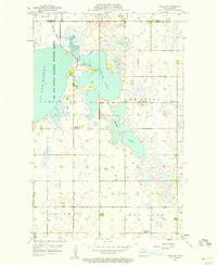
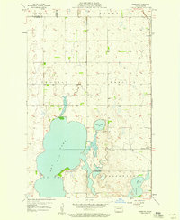
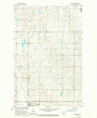
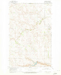
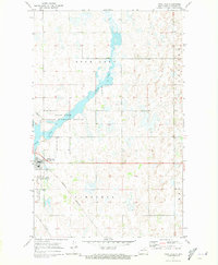
 1953 Devils Lake1968 Print · USGSNorth Dakota's northern plains are captured here in the mid-fifties, showing a landscape of rail-fed grain elevators and prairie wetlands. Genealogists can locate family landmarks like Rose Hill School, Hurricane Lake Church, and the Turtle Mountain Indian Reservation.3 unique versions available
 - 1956 Map of Devils Lake
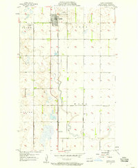
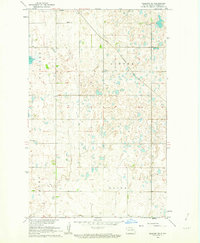
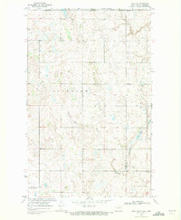
 1956 Devils Lake1956 Print · USGSNorthern North Dakota is shown at a mid-century peak of rail-driven agriculture, where the Soo Line and Great Northern railroads cross the prairie. Trace the borders of the Turtle Mountain Indian Reservation and locate local landmarks like Rose Hill School or Camp Grafton.
 - 1957 Map of Cando SE, 1958 Print
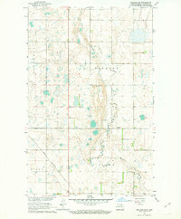
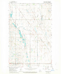
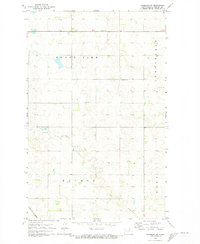
 1957 Cando SE1958 Print · USGSThe lakeside prairie of Ramsey and Towner counties is captured here in the late fifties, showing a landscape defined by seasonal waters and rural shifts. Researchers can locate specific heritage sites like the Almira Cem, Chain Lakes Ch, and former schoolhouses like School No 9 (Abandoned).2 unique versions available
 - 1957 Map of Cando, 1958 Print
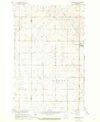
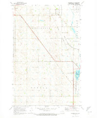
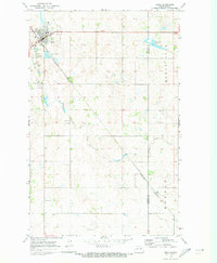
 1957 Cando1958 Print · USGSCando and the surrounding Towner County prairie are captured in the late fifties, dominated by the vital rail corridor of the GREAT NORTHERN. Genealogists can locate family sites at Olson Cem and Cando Cem, or trace the rural school district at Gopher Sch No 4.
 - 1957 Map of Cando NE, 1958 Print
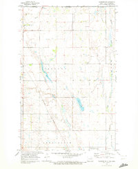
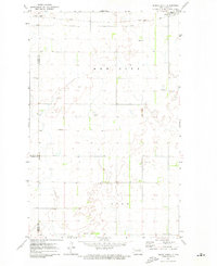
 1957 Cando NE1958 Print · USGSTowner County's prairie wetlands and township divisions are meticulously captured in the late fifties. Genealogists and historians can trace the local landscape through features like School No 1, the Gaging Station, and the edges of the Lac Aux Mortes National Wildlife Refuge.
 - 1957 Map of Churchs Ferry, 1958 Print
 1957 Churchs Ferry1958 Print · USGSChurchs Ferry and Maza are centers of North Dakota rail and lake life in the late fifties. Genealogists and local historians can trace the Great Northern rail lines and find specific family landmarks like Zion Cem or the edges of Lake Irvine.
 - 1957 Map of Webster, 1958 Print
 1957 Webster1958 Print · USGSRamsey County's prairie landscape is captured here in the late fifties, as the grain-dependent rail economy shaped the local plains. Genealogists and historians can trace the tracks of the Great Northern through Webster and Garske or locate the Webster Cem.
 - 1962 Map of Egeland SE, 1963 Print
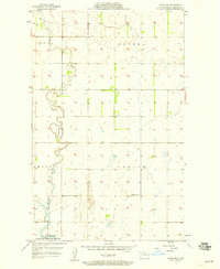
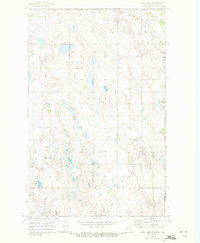
 1962 Egeland SE1963 Print · USGSTowner County's prairie landscape is captured in the early sixties as it was being developed under the Missouri River Basin program. Genealogists and local historians can trace the Great Northern rail line and locate the Egeland Cem and the settlement of Egeland.
 - 1962 Map of Egeland SW, 1963 Print
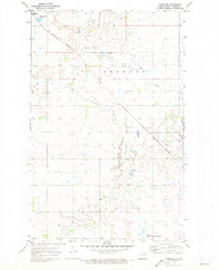
 1962 Egeland SW1963 Print · USGSTowner County in the early sixties reveals a prairie landscape structured by township lines and family-named tracts. Researchers can trace the Great Northern rail route and locate rural industry at the Gravel Pits along Mauvais Coulee.
 - 1962 Map of Starkweather, 1964 Print
 1962 Starkweather1964 Print · USGSThe rural prairie landscape around Starkweather is captured here in the early sixties, showing a region defined by the Great Northern rail line. Researchers can trace the Towner and Ramsey County line or locate local landmarks like Bergen Ch and Davis Slough.
 - 1962 Map of Egeland, 1964 Print
 1962 Egeland1964 Print · USGSTowner County's rail-dependent agricultural landscape comes into focus in the early sixties at the junction of two major lines. Genealogists and historians can trace the early footprints of Egeland, the sidings at Olmstead, and the rural township divisions of Crocus and Victor.
 - 1962 Map of Snyder Lake, 1964 Print
 1962 Snyder Lake1964 Print · USGSTowner County’s railway and wildlife corridors are captured here in the early sixties, showing a landscape of small settlements and prairie coulees. Trace local family history at Brumbaugh Cem and Zion Cem or follow the paths of the Soo Line and Great Northern railroads.
 - 1969 Map of Hansboro NE, 1972 Print
 1969 Hansboro NE1972 Print · USGSThe North Dakota borderlands near the close of the 1960s reveal a landscape of prairie wetlands and international transit points. Researchers can trace the Burlington Northern line through Hansboro or locate the US Customs station at the Canadian line.
 - 1969 Map of Rock Lake NE, 1972 Print
 1969 Rock Lake NE1972 Print · USGSThe international border between North Dakota and Manitoba takes center stage in this late 1960s survey of the high plains. Researchers can trace the layout of Sarles on the county line or locate local landmarks like Dash Cem and the township of Loansing.
 - 1969 Map of Hansboro, 1972 Print
 1969 Hansboro1972 Print · USGSThe international border near Hansboro is captured here during the late sixties, showcasing a landscape of prairie coulees and rural townships. Researchers can trace the Burlington Northern rail line and explore the Armourdale Lake State Game Management Area.
 - 1969 Map of Rock Lake NW, 1972 Print
 1969 Rock Lake NW1972 Print · USGSThe international border in Towner County meets a landscape of prairie potholes and wetlands during the late sixties. Researchers can trace the northern waters of Rock Lake and locate rural landmarks like the local townhall and benchmarks such as BM 1529.
 - 1969 Map of Rolla NE, 1972 Print
 1969 Rolla NE1972 Print · USGSThe northern boundary of North Dakota meets the Canadian border in the late sixties, showing a landscape defined by prairie coulees and rural townships. Researchers can trace the path of Hidden Island Coulee or locate the Rolla Municipal Airport and the nearby Country Club.
 - 1970 Map of Hansboro SW, 1973 Print
 1970 Hansboro SW1973 Print · USGSTowner County's prairie landscape is captured in the early 1970s, showing the intersection of rural townships and rail corridors. Genealogists and local historians can locate the Mount View Cem, Finnish Cem, and the old Townhall.
 - 1970 Map of Hansboro SE, 1973 Print
 1970 Hansboro SE1973 Print · USGSTowner County's prairie landscape is captured here in the early 1970s, as two major railroads intersected near the small settlement of Armourdale. Researchers can locate family sites near All Nations Cem or trace the shoreline of the Rock Lake National Wildlife Refuge.
 - 1970 Map of Rock Lake, 1973 Print
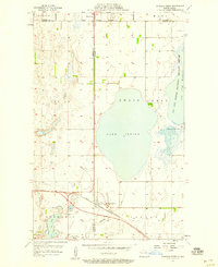
 1970 Rock Lake1973 Print · USGSThe northern plains of Towner County are captured in the early 1970s, centered on the town of Rock Lake and its vital rail corridors. Trace the path of the Burlington Northern and Soo Line railroads as they meet near the Rock Lake National Wildlife Refuge.
 - 1970 Map of Rolla, 1973 Print
 1970 Rolla1973 Print · USGSThe northern plains around Rolla are captured here in the early seventies, detailing a landscape defined by the intersection of rail and road. Researchers can trace the Burlington Northern tracks and locate St Michael Cem or Emanuel Cem.
 - 1970 Map of Rock Lake SE, 1973 Print
 1970 Rock Lake SE1973 Print · USGSTowner and Cavalier counties appear as a mosaic of prairie potholes and agricultural sections in the early 1970s. Researchers can locate the rural Ellison Cem or trace the township boundaries of Lansing and Teddy across this prairie landscape.
 - 1971 Map of Bisbee South, 1973 Print
 1971 Bisbee South1973 Print · USGSTowner County and Rolette County are captured in the early 1970s, showcasing a rural prairie landscape defined by the Soo Line and family-named cemeteries. Researchers can trace local heritage at Teubner Cem, Halling Cem, and the old Townhall.
 - 1971 Map of Considine, 1973 Print
 1971 Considine1973 Print · USGSTowner County in the early seventies shows a landscape of rail-centered agriculture and prairie wetlands. Genealogists and historians can trace the rail sidings of the Burlington Northern between Bisbee and Considine, and locate the northern edges of the Johnson National Wildlife Refuge.
 - 1971 Map of Leeds NE, 1973 Print
 1971 Leeds NE1973 Print · USGSTowner County in the early 1970s is a landscape of conservation and prairie wetlands at the height of the national wildlife refuge system. Local historians can trace the bounds of Johnson National Wildlife Refuge or locate landmarks in Springfield and Olson.
Showing maps 1-25 of 198
Top cities of Towner County
- Cando historical maps
- Bisbee historical maps
- Crocus historical maps
- Egeland historical maps
- Maza historical maps
- Perth historical maps
See more
Frequently asked questions
- What are the different types of historical maps available for Towner County?
- What is the oldest map of Towner County?
- Where can I purchase historical maps of Towner County for my home or office?
- Where can I download high-res historical maps of Towner County?
- Are there historical topographic maps available for Towner County?
- Is there historical aerial imagery available for Towner County?
- Where are historical maps of Towner County sourced from?