1980s Maps of Towner County, North Dakota
Explore 4 historic maps of Towner County from the 1980s. These maps offer a rare glimpse into what life looked like during the 1980s — showing old roads, neighborhoods, homes, and landmarks that have changed or disappeared over time.
Whether you're researching your family's past, planning a metal detecting trip, or studying how Towner County's landscape evolved across the 1980s, these high-resolution maps are a powerful tool for exploring the history of this region.
- Focus on a specific era: All maps on this page are from the 1980s, giving you a focused view of this time period.
- See what’s changed: Compare century-old streets, trails, and buildings to today's modern landscape using overlays and satellite layers.
- Research with precision: Use these maps for genealogy, historical research, land use analysis, or educational projects.
- View, download, or print: Maps are fully viewable online in high resolution, and can be downloaded or printed for your own records.
Start exploring Towner County's history through authentic maps from the 1980s. This is your window into the past.
Towner County, ND maps
(4)- 1985 Map of Langdon
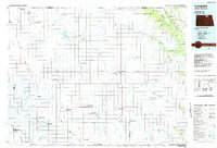 1985 Langdon1985 Print · USGSCavalier County and the surrounding prairie are captured here in the mid-1980s as the rail-and-agriculture economy shaped the landscape. Researchers can trace rural lineages through dozens of small settlements like Munich, Nekoma, and Osnabrock, or follow the lines of the Burlington Northern and Soo Line railroads.2 unique versions available
 - 1985 Map of Devils Lake
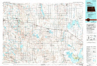
 1985 Devils Lake1985 Print · USGSThe Ramsey County lake region is captured here in the mid-1980s as a vital hub of wildlife management and grain transport. Researchers can trace the sprawling boundaries of the Fort Totten Indian Reservation and locate local landmarks like Lake Region Jr College and Whitman Dam.
 - 1985 Map of Rock Lake, 1986 Print
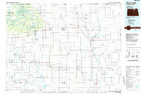 1985 Rock Lake1986 Print · USGSThe North Dakota borderlands and the forested heights of the Turtle Mountains are documented here in the mid-eighties. Genealogists and historians can trace the rail lines of the Soo Line through prairie towns like Bisbee, Rolette, and Rolla.2 unique versions available
 - 1985 Map of Leeds, 1994 Print
 1985 Leeds1994 Print · USGSBenson and Ramsey counties are shown during the mid-eighties as a patchwork of prairie agriculture and vital wetland habitats. Researchers can locate family roots at Knox Cem, trace the Soo Line rail corridors, or explore the fringes of Devils Lake.
End of results
Showing maps 1-4 of 4
Top cities of Towner County
- Cando historical maps
- Bisbee historical maps
- Crocus historical maps
- Egeland historical maps
- Maza historical maps
- Perth historical maps
See more
Frequently asked questions
- What are the different types of historical maps available for Towner County?
- What is the oldest map of Towner County?
- Where can I purchase historical maps of Towner County for my home or office?
- Where can I download high-res historical maps of Towner County?
- Are there historical topographic maps available for Towner County?
- Is there historical aerial imagery available for Towner County?
- Where are historical maps of Towner County sourced from?