1960s Maps of Towner County, North Dakota
Explore 10 historic maps of Towner County from the 1960s. These maps offer a rare glimpse into what life looked like during the 1960s — showing old roads, neighborhoods, homes, and landmarks that have changed or disappeared over time.
Whether you're researching your family's past, planning a metal detecting trip, or studying how Towner County's landscape evolved across the 1960s, these high-resolution maps are a powerful tool for exploring the history of this region.
- Focus on a specific era: All maps on this page are from the 1960s, giving you a focused view of this time period.
- See what’s changed: Compare century-old streets, trails, and buildings to today's modern landscape using overlays and satellite layers.
- Research with precision: Use these maps for genealogy, historical research, land use analysis, or educational projects.
- View, download, or print: Maps are fully viewable online in high resolution, and can be downloaded or printed for your own records.
Start exploring Towner County's history through authentic maps from the 1960s. This is your window into the past.
Towner County, ND maps
(10)- 1962 Map of Egeland SE, 1963 Print
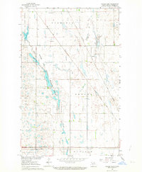
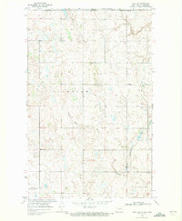
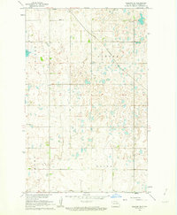 1962 Egeland SE1963 Print · USGSTowner County's prairie landscape is captured in the early sixties as it was being developed under the Missouri River Basin program. Genealogists and local historians can trace the Great Northern rail line and locate the Egeland Cem and the settlement of Egeland.
 - 1962 Map of Egeland SW, 1963 Print
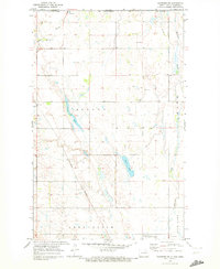
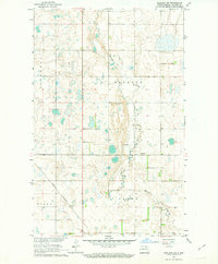 1962 Egeland SW1963 Print · USGSTowner County in the early sixties reveals a prairie landscape structured by township lines and family-named tracts. Researchers can trace the Great Northern rail route and locate rural industry at the Gravel Pits along Mauvais Coulee.
 - 1962 Map of Starkweather, 1964 Print
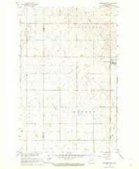 1962 Starkweather1964 Print · USGSThe rural prairie landscape around Starkweather is captured here in the early sixties, showing a region defined by the Great Northern rail line. Researchers can trace the Towner and Ramsey County line or locate local landmarks like Bergen Ch and Davis Slough.
 - 1962 Map of Egeland, 1964 Print
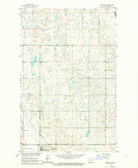 1962 Egeland1964 Print · USGSTowner County's rail-dependent agricultural landscape comes into focus in the early sixties at the junction of two major lines. Genealogists and historians can trace the early footprints of Egeland, the sidings at Olmstead, and the rural township divisions of Crocus and Victor.
 - 1962 Map of Snyder Lake, 1964 Print
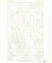
 1962 Snyder Lake1964 Print · USGSTowner County’s railway and wildlife corridors are captured here in the early sixties, showing a landscape of small settlements and prairie coulees. Trace local family history at Brumbaugh Cem and Zion Cem or follow the paths of the Soo Line and Great Northern railroads.
 - 1969 Map of Hansboro NE, 1972 Print
 1969 Hansboro NE1972 Print · USGSThe North Dakota borderlands near the close of the 1960s reveal a landscape of prairie wetlands and international transit points. Researchers can trace the Burlington Northern line through Hansboro or locate the US Customs station at the Canadian line.
 - 1969 Map of Rock Lake NE, 1972 Print
 1969 Rock Lake NE1972 Print · USGSThe international border between North Dakota and Manitoba takes center stage in this late 1960s survey of the high plains. Researchers can trace the layout of Sarles on the county line or locate local landmarks like Dash Cem and the township of Loansing.
 - 1969 Map of Hansboro, 1972 Print
 1969 Hansboro1972 Print · USGSThe international border near Hansboro is captured here during the late sixties, showcasing a landscape of prairie coulees and rural townships. Researchers can trace the Burlington Northern rail line and explore the Armourdale Lake State Game Management Area.
 - 1969 Map of Rock Lake NW, 1972 Print
 1969 Rock Lake NW1972 Print · USGSThe international border in Towner County meets a landscape of prairie potholes and wetlands during the late sixties. Researchers can trace the northern waters of Rock Lake and locate rural landmarks like the local townhall and benchmarks such as BM 1529.
 - 1969 Map of Rolla NE, 1972 Print
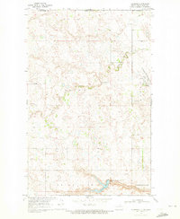
 1969 Rolla NE1972 Print · USGSThe northern boundary of North Dakota meets the Canadian border in the late sixties, showing a landscape defined by prairie coulees and rural townships. Researchers can trace the path of Hidden Island Coulee or locate the Rolla Municipal Airport and the nearby Country Club.
End of results
Showing maps 1-10 of 10
Top cities of Towner County
- Cando historical maps
- Bisbee historical maps
- Crocus historical maps
- Egeland historical maps
- Maza historical maps
- Perth historical maps
See more
Frequently asked questions
- What are the different types of historical maps available for Towner County?
- What is the oldest map of Towner County?
- Where can I purchase historical maps of Towner County for my home or office?
- Where can I download high-res historical maps of Towner County?
- Are there historical topographic maps available for Towner County?
- Is there historical aerial imagery available for Towner County?
- Where are historical maps of Towner County sourced from?