
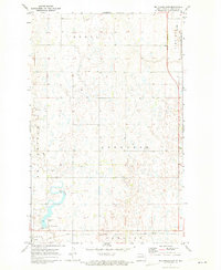
1962 Map of Snyder Lake
USGS Topo · Published 1964About this map
The prairie landscape of Towner County is defined here by the intersection of early North Dakota rail infrastructure and vital water conservation efforts. Two major rail lines, the Great Northern and the Soo Line, cross through the townships of Crocus and Virginia, signaling the agricultural importance of the region in the early 1960s. The presence of the Snyder Lake National Wildlife Refuge and Brumba National Wildlife Refuge highlights the ecological significance of the coulee systems. Local history is anchored by the small settlements of Arndt and Crocus, while family genealogy is preserved at Brumbaugh Cem and Zion Cem. This survey illustrates a period where small-scale gravel extraction and the management of Snyder Lake were central to the local economy and land use.
Find a feature on this map
20 named features on this map. Tap any name to fly to it.
Don’t see what you’re looking for? This feature index may not catch every label — zoom into the map to look around manually.
Map Details
Editions of this 1962 Snyder Lake Map
This is the sole edition of this map. No revisions or reprints were ever made.
Other maps of this area

1953 · Devils Lake
USGS Topo · 1:250,000

1956 · Devils Lake
USGS Topo · 1:250,000

1962 · Egeland SE
USGS Topo · 1:24,000

1962 · Egeland SW
USGS Topo · 1:24,000

1962 · Egeland
USGS Topo · 1:24,000

1970 · Hansboro SE
USGS Topo · 1:24,000

1970 · Rock Lake
USGS Topo · 1:24,000

1970 · Rock Lake SE
USGS Topo · 1:24,000

1971 · Considine
USGS Topo · 1:24,000
1971 · Big Coulee Dam
USGS Topo · 1:24,000